
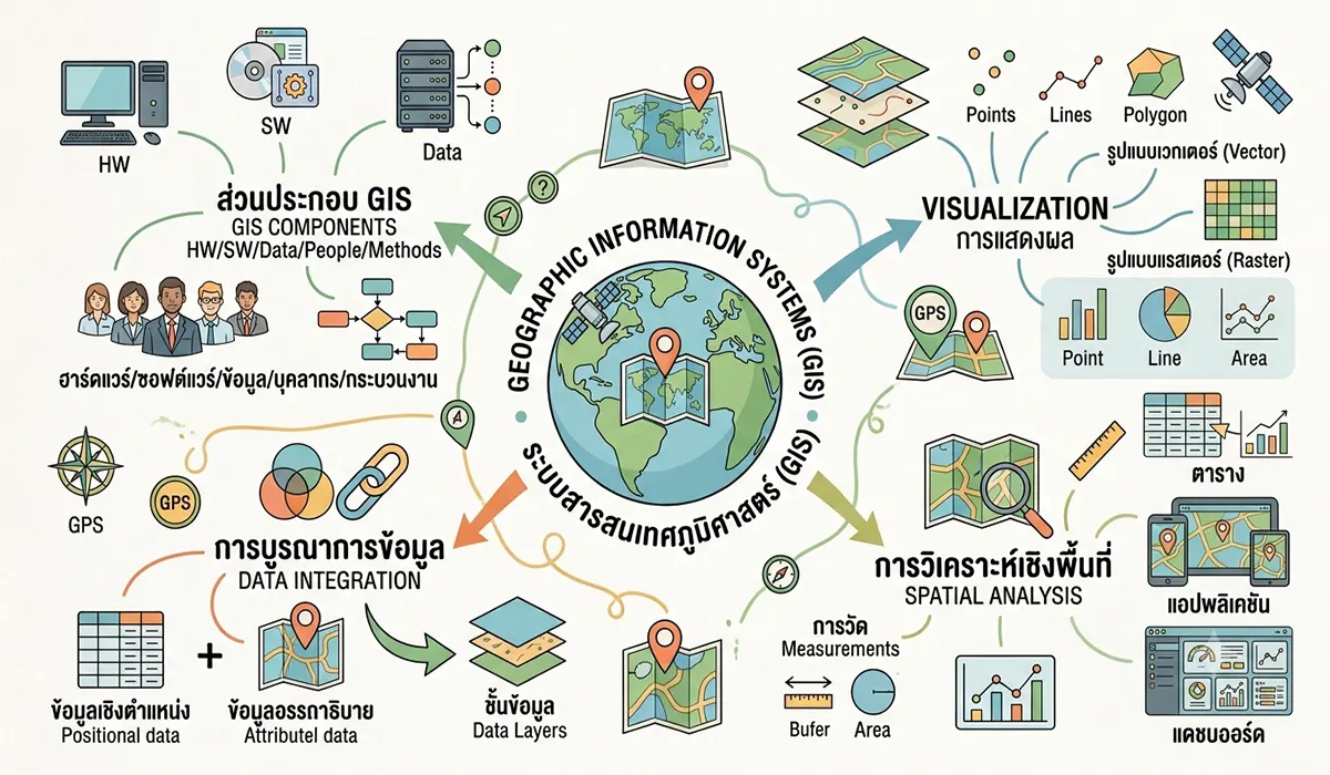
ภาพประกอบสร้างโดยเทคโนโลยี AI (Visual enhanced by AI technology)
ระบบสารสนเทศภูมิศาสตร์ (Geographic Information System: GIS) เป็นเครื่องมือสำคัญในการจัดการ วิเคราะห์ และแสดงผลข้อมูลเชิงพื้นที่ โดยระบบ GIS มีองค์ประกอบที่ต้องทำงานร่วมกันอย่างเป็นระบบ คือ ฮาร์ดแวร์ (Hardware) ซอฟต์แวร์ (Software) ข้อมูล (Data) บุคลากร (People) และกระบวนการทำงาน (Methods) โดยกระบวนการทำงานของ GIS ประกอบด้วย การเก็บรวบรวมข้อมูล (Data Collection) การจัดเก็บและจัดการข้อมูล (Data Management) การวิเคราะห์ข้อมูล (Spatial Analysis) และการแสดงผล (Visualization)
สำหรับข้อมูลในระบบ GIS ประกอบด้วยการผสานข้อมูลเชิงตำแหน่งกับข้อมูลเชิงคุณลักษณะเข้าด้วยกัน (Data Integration) โดยข้อมูลเชิงตำแหน่งในระบบ GIS จะถูกแยกเป็นชั้นข้อมูลอย่างชัดเจน
ในการวิเคราะห์ข้อมูล (Spatial Analysis) เป็นขั้นตอนสำคัญของการนำข้อมูลมาผสมผสานและวิเคราะห์โดยอาศัยเทคนิคขั้นพื้นฐาน เช่น การค้นหาข้อมูล การตรวจวัดข้อมูลเชิงพื้นที่ (การวัดระยะ วัดพื้นที่ วัดความสูง วัดความลาดชัน ฯลฯ) และการวิเคราะห์ด้วยเทคนิคที่ซับซ้อนขึ้น เช่น การใช้ overlay Technique การทำ Buffering การทำ Generalization เป็นต้น
สำหรับการแสดงผลข้อมูล (Visualization) นั้น ระบบ GIS สามารถนำเสนอข้อมูลในรูปแบบแผนที่หรือกราฟ ตารางข้อมูล การทำ Application โดยระบบ GIS จะมีลักษณะเด่นในการแสดงผลแผนที่ คือ แผนที่สามารถเชื่อมโยงกับข้อมูลรูปแบบอื่น ๆ ได้ในเวลาเดียวกัน ดังนั้น นอกจากการแสดงผลข้อมูลเพื่อการนำเสนอเป็นครั้ง ๆ แล้ว ระบบ GIS ยังสามารถแสดงผลในรูป Dashboard ซึ่งเป็นข้อมูลในลักษณะ Real Time ได้ด้วย
A Geographic Information System (GIS) is a powerful framework for managing, analyzing, and visualizing spatial information. It integrates geographic data with analytical tools to support decision-making, planning, and problem-solving across a wide range of disciplines. A GIS operates through the coordinated interaction of five fundamental components: hardware, software, data, people, and methods.
The GIS workflow typically consists of four major stages: data collection, data management, spatial analysis, and visualization. These stages enable geographic information to be acquired, organized, analyzed, and communicated efficiently.
A fundamental characteristic of GIS is data integration, in which spatial data (location-based information) are linked with attribute data (descriptive information). Spatial data are commonly organized into multiple thematic layers, allowing different geographic features and phenomena to be stored, managed, and analyzed independently while maintaining their spatial relationships.
Spatial analysis is the core function of GIS. It involves integrating and analyzing spatial datasets using a variety of analytical techniques. Basic GIS operations include data querying, distance measurement, area calculation, elevation analysis, slope analysis, and other forms of spatial measurement. More advanced analytical techniques include overlay analysis, buffer analysis, generalization, network analysis, spatial interpolation, and numerous other geoprocessing methods that reveal spatial relationships, patterns, and trends.
For visualization, GIS presents geographic information in multiple formats, including maps, charts, tables, reports, and interactive applications. One of the distinguishing features of GIS is its ability to dynamically link maps with related datasets, enabling users to explore geographic information together with statistical, textual, photographic, or multimedia data within a single environment. Beyond producing conventional maps for reporting and presentation, modern GIS also supports interactive dashboards that integrate multiple data sources and display real-time geographic information, providing timely insights for monitoring, analysis, and decision-making.