

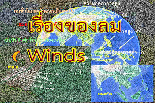


ลม คือ อากาศที่เคลื่อนที่จากบริเวณหนึ่งไปยังอีกบริเวณหนึ่งซึ่งเกิดจากความแตกต่างของอุณหภูมิ ความกดอากาศของ 2 พื้นที่ โดยลมจะพัดจากบริเวณที่มีอุณหภูมิต่ำซึ่งมีความกดอากาศสูงเข้าสู่บริเวณที่อุณหภูมิสูงซึ่งมีความกดอากาศต่ำ
Wind is the movement of air from one area to another, resulting from temperature differences and air pressure variances between the two regions. The wind blows from an area with low temperature and high air pressure to an area with high temperature and low air pressure.
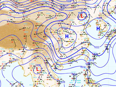
บริเวณที่มีอุณหภูมิสูงจะมีความกดอากาศต่ำ เนื่องจากอุณหภูมิสูง อากาศขยายตัวทำให้มีความหนาแน่นต่ำ อากาศจะลอยไปข้างบน ส่วนบริเวณที่มีอุณหภูมิต่ำ ความหนาแน่นของอากาศจะมากทำให้เป็นบริเวณที่มีความกดอากาศสูง สำหรับแผนที่อากาศจะใช้เส้นไอโซบาร์ (Isobar) เป็นแนวบอกค่าระดับความกดอากาศสูงหรือต่ำ (การอ่านค่าคล้ายกับการอ่าน Contour line) และใช้อักษร H และ L บอกบริเวณหย่อมความกดอากาศ โดยหย่อมความกดอากาศสูงใช้อักษร H หย่อมความกดอากาศต่ำใช้อักษร L
In areas with high temperatures, air pressure is low due to the expansion of air molecules, resulting in low density. The air rises, creating low-pressure areas. Conversely, in regions with low temperatures, the air density is higher, leading to high-pressure zones. Weather maps use isobars as contour lines to indicate the levels of high or low air pressure (similar to reading contour lines). The letter 'H' is used to denote high-pressure areas, while 'L' is used for low-pressure areas.
หากพิจารณาการเคลื่อนตัวของอากาศรอบโลกจะพบว่า
A brief explanation of the movement of air around the globe is as follows:
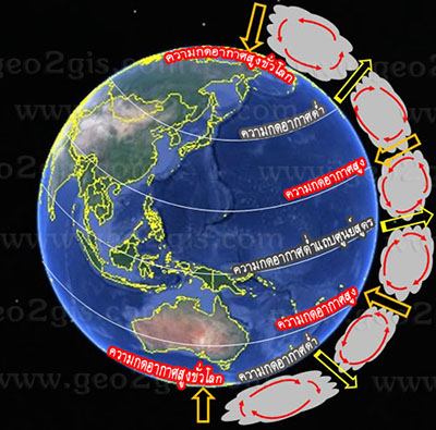
บริเวณเขตเส้นศูนย์สูตรเป็นบริเวณที่ได้รับแสงอาทิตย์ตลอดทั้งปีมีอุณหภูมิสูง อากาศร้อนจะลอยตัวสูงขึ้น(ความกดอากาศต่ำ) ไปจนถึงชั้นบรรยากาศโทรโปสเฟียร์ ซึ่งอากาศจะลอยไม่เกินระดับนี้ อากาศร้อนนี้จึงแผ่ออกไปยังขั้วโลกเหนือและใต้ และเมื่ออากาศร้อนที่แผ่ออกไปปะทะกับอากาศที่เย็นอุณหภูมิก็จะเริ่มลดลงจนถึงบริเวณแถบละติจูด 30° เหนือและใต้ของเส้นศูนย์สูตร อากาศที่เย็นลงเรื่อยๆ (ความกดอากาศสูง) ก็จะจมลงสู่ผิวโลก แต่เนื่องจากอากาศนี้มีความชื้นต่ำจึงทำให้บริเวณนี้แห้ง จึงพบทะเลทรายส่วนใหญ่ของโลกอยู่ในบริเวณนี้
The area along the equator is a region that receives sunlight throughout the year, resulting in high temperatures. The warm air rises, creating low-pressure areas, ascending until it reaches the tropopause. At this level, the air ceases to rise. The warm air then moves towards the Earth's poles, both north and south. When the warm air encounters the cooler air, its temperature begins to decrease, reaching the region around the 30° latitude belts north and south of the equator. The progressively cooler air, characterized by high pressure, descends to the Earth's surface. However, due to the low humidity in this air mass, the region becomes arid, and it is in this area that the majority of the world's deserts are found.
อากาศเย็นที่บริเวณเส้นละติจูด 30° เหนือและใต้ ที่จมตัวลงพื้นผิวโลกเนื่องจากความกดอากาศสูงจะถูกกดและผลักให้ไหลไปยังบริเวณที่มีความกดอากาศต่ำบริเวณเส้นศูนย์สูตร จนถึงบริเวณใกล้เส้นศูนย์สูตรและหมดกำลังทำให้เกิดเขตลมสงบ หรือลมอ่อน (doldrums)
Cool air at the latitude belts around 30° north and south sinks to the Earth's surface due to high air pressure, gets compressed, and is then pushed towards the regions with low air pressure along the equator. This process continues until reaching the vicinity of the equator, where the forces balance out, resulting in the creation of a calm and light wind zone known as the doldrums.
ในขณะที่อากาศเย็นตัวที่จมลงกลับสู่ผิวโลกที่บริเวณเส้นละติจูด 30° เหนือและใต้ที่จมตัวลงพื้นผิวโลกเนื่องจากความกดอากาศสูงอีกส่วนหนึ่ง จะถูกกดและผลักให้ไหลไปทางขั้วโลกเหนือและใต้ และไปปะทะกับอากาศเย็นจากขั้วโลก แถบบริเวณเส้นละติจูด 60° เหนือและใต้ จึงเรียกบริเวณนี้ว่า แนวปะทะขั้วโลก (polar fronts) การปะทะกันของอากาศที่มีอุณหภูมิต่างกัน ทำให้อากาศร้อนกว่าลอยตัวขึ้นโดยส่วนหนึ่งไหลย้อนกลับไปทางเส้นศูนย์สูตร ก่อนที่จะจมตัวลงแถบบริเวณเส้นละติจูด 30° เหนือและใต้อีกครั้งทำให้เกิดความกดอากาศสูงที่บริเวณนี้เพิ่มขึ้น อีกส่วนหนึ่งไหลเคลื่อนไปยังเขตขั้วโลกเหนือและใต้ปะทะกับอากาศเย็นขั้วโลกและจมลง แล้วไหลย้อนกลับไปยังบริเวณเส้นละติจูด 60° เหนือและใต้
While the sinking cool air returns to the Earth's surface around the latitude belts of 30° north and south, driven by high air pressure, another portion of it is compressed and propelled towards the Earth's poles, both north and south. It then meets with the cold air from the polar regions around the latitude belts of 60° north and south. We know this area as the polar fronts, where the collision of air masses with different temperatures occurs. The warmer air, in part, rises and flows back towards the equator before sinking again in the latitude belts around 30° north and south. This process leads to the formation of high air pressure in this region. Another portion of the air moves towards the polar regions, collides with the cold air there, and sinks, then flows back towards the latitude belts of 60° north and south.
ประเภทของลมสามารถแบ่งตามลักษณะการเกิด พื้นที่ที่เกิด และช่วงเวลาการเกิด ได้ดังนี้
The types of winds can be classified based on their characteristics of origin, the areas where they occur, and the time of their occurrence, as follows:
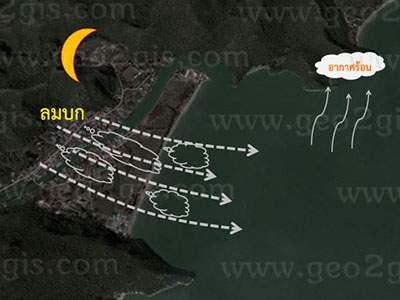
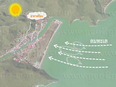
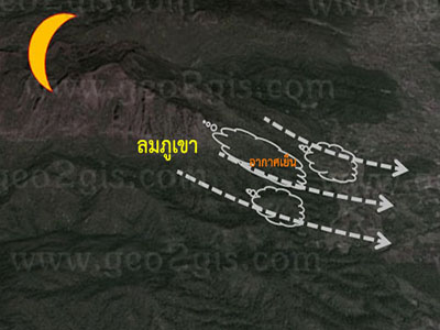
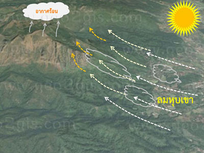
1. ลมประจำเวลา (Diurnal Wind) หรือ ลมเฉื่อย (Breeze)
2. ลมประจำถิ่น (Local Wind)
3. ลมประจำปี (Prevailing Wind)
4. ลมประจำฤดู (Seasonal Wind)
5. ลมแปรปรวนหรือลมพายุ (Storm)
1. ลมประจำเวลา (Diurnal Wind) หรือ ลมเฉื่อย (Breeze)
เป็นลมที่มักจะเกิดในบริเวณหนึ่งๆ ในช่วงเวลาต่างกันในรอบวัน คือ กลางวันและกลางคืน โดยจะเกิดบริเวณพื้นที่ที่ใกล้กันแต่มีลักษณะภูมิประเทศแตกต่างกัน ซึ่งในเวลากลางวันและกลางคืนอุณหภูมิระหว่างสองพื้นที่จะต่างกันด้วย ลมประจำเวลา ได้แก่ ลมบก-ลมทะเล ลมหุบเขา-ลมภูเขา
These are winds that tend to occur in specific regions during different times of the day daytime and nighttime. They typically manifest in areas close to each other but with varying topographical features. The temperatures between these two regions differ during daytime and nighttime. Periodic winds include land breezes and sea breezes, as well as mountain winds and valley winds.
2. ลมประจำถิ่น (Local Wind)
เป็นลมที่เกิดในแต่ละท้องถิ่นตามลักษณะภูมิประเทศโดยเฉพาะ โดยจะมีชื่อเรียกตามสถานที่เกิดบริเวณนั้น เช่น ลมตะเภา ลมบ้าหมู ลมทะเลทราย (Desert Winds)
These are winds that occur in each region according to the specific topographical features of that area. We often name them based on the location where they originate, such as trade winds, whirlwinds, and desert winds.
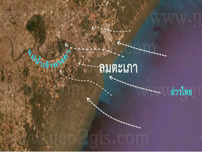
ลมตะเภาซึ่งเป็นลมที่พัดจากอ่าวไทยขึ้นไปยังแม่น้ำเจ้าพระยาในฤดูร้อน
The trade winds blow from the Gulf of Thailand towards the Chao Phraya River during the summer.
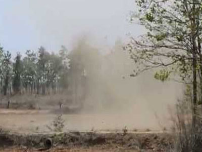
ลมบ้าหมู เป็นลมหมุนขนาดเล็กเกิดในช่วงร้อนจัด โดยจะเกิดบริเวณที่โล่งๆหมุนขึ้นไปข้างบน
Whirlwinds are small-scale rotating winds that occur during intense heat, typically in open areas, spiraling upward.
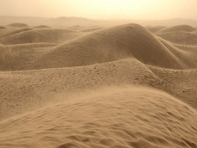
ลมทะเลทราย เป็นลมท้องถิ่นเกิดขึ้นในบริเวณทะเลทราย เวลาเกิดจะมาพร้อมกับพายุฝุ่นหรือพายุทราย เป็นลมร้อนและแห้ง บริเวณที่เกิดได้แก่ ทางด้านเหนือของทวีปแอฟริกา บริเวณทะเลทราย ทางตะวันตกเฉียงใต้ของสหรัฐอเมริกา
Desert winds are local winds that occur in desert areas, often accompanying dust storms or sandstorms. They are hot and dry winds. Regions where these winds occur include the northern part of the African continent, particularly in desert areas, and the southwestern part of the United States.
3. ลมประจำปี (Prevailing Wind)
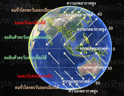
เป็นลมที่เกิดจากความกดอากาศที่มีอยู่เดิมตลอดปี เนื่องจากบริเวณขั้วโลกและบริเวณเส้นศูนย์สูตรได้รับความร้อนจากดวงอาทิตย์ไม่เท่ากัน บริเวณที่มีมวลอากาศน้อยเนื่องจากร้อนมากอากาศลอยตัว เรียกว่า หย่อมความกดอากาศต่ำ (Low pressure) บริเวณที่มีมวลอากาศมากเนื่องจากอากาศเย็นอากาศจึงจมตัว เรียกว่า หย่อมความกดอากาศสูง (High pressure) ซึ่งอากาศจมตัวเคลื่อนไปแทนที่อากาศที่ลอยตัวทำให้เกิดลมพัดผ่านส่วนต่าง ๆ ของโลก ลมประจำปี ได้แก่ ลมสินค้า ลมฝ่ายตะวันตก และลมขั้วโลก
Winds that result from the pre-existing air pressure throughout the year, as the polar and equatorial regions receive unequal heating from the sun. The region with low air mass, due to excessive heat, is referred to as a low-pressure area. The region with a high air mass, as the cool air sinks, is called a high-pressure area. As the sinking air displaces the floating air, winds are generated across various parts of the globe. Seasonal winds include trade winds, westerlies, and polar easterlies.
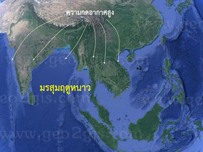
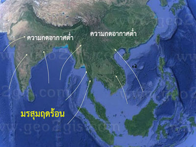
4. ลมประจำฤดู (Seasonal Wind)
เป็นลมที่เกิดขึ้นในภูมิภาคบริเวณกว้างและเป็นลมที่พัดเป็นเวลานานตลอดฤดูของทุกปี ได้แก่ ลมมรสุม สำหรับทิศทางการพัดนั้นขึ้นอยู่ฤดู เป็นลมที่มีการเปลี่ยนแปลงทิศทางของลมที่พัดจากฤดูหนึ่งไปยังอีกฤดูหนึ่งในทิศทางตรงกันข้าม และเกิดขึ้นในภูมิภาคเอเชียตะวันออก และเอเชียตะวันออกเฉียงใต้ และเอเชียใต้เนื่องจากทวีปเอเชียมีขนาดใหญ่ความแตกต่างระหว่างอุณหภูมิของพื้นดินและน้ำจึงต่างกันมาก การเกิดลมมรสุมแบ่งได้ 2 ชนิด คือ ลมมรสุมตะวันตกเฉียงใต้หรือมรสุมฤดูร้อน และลมมรสุมตะวันออกเฉียงเหนือหรือ มรสุมฤดูหนาว
Winds that occur in vast geographical regions and persist for an extended duration throughout the year include monsoons. The predominant wind direction depends on the season, and these winds undergo a reversal in direction between opposing seasons. They occur in the Asian monsoon regions, including East Asia, Southeast Asia, and South Asia. The large size of the Asian continent leads to significant temperature differences between land and water. We can categorize monsoons into two types: the Southwest Monsoon or summer monsoon and the Northeast Monsoon or winter monsoon.
5. ลมแปรปรวนหรือลมพายุ (Storm) เป็นลมที่เกิดขึ้นอย่างรุนแรงเนื่องจากความกดอากาศที่แตกต่างกันมากจึงทำให้เกิดลมที่มีความรุนแรงมาก ได้แก่ พายุฝนฟ้าคะนอง พายุเขตร้อน
Turbulent winds or storms are strong winds that occur due to significant differences in air pressure, resulting in highly intense winds. Examples
include thunderstorms and tropical cyclones.
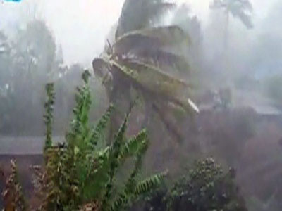
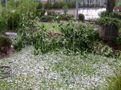
พายุฝนฟ้าคะนอง เกิดจากการเปลี่ยนกดอากาศอย่างรวดเร็วในช่วงเดือนพฤษภาคมทำให้มีพายุ ลมแรง ฝนตกหนัก ฟ้าร้อง ฟ้าผ่า ลูกเห็บตก
Thunderstorms, generated by rapid changes in air pressure, typically occur during May, resulting in strong winds, heavy rainfall, thunder, lightning, and hail.
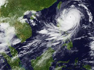
พายุเขตร้อน เป็นพายุที่เกิดจากการปะทะของความกดอากาศ โดยบริเวณศูนย์กลางจะมีความกดอากาศที่ต่ำกว่าบริเวณรอบๆ จนเกิดพายุหมุน
The collision of air pressures, where the central region experiences lower air pressure than the surrounding areas, results in a cyclone forming a tropical storm.