
อากาศที่เคลื่อนที่จากบริเวณหนึ่งไปยังอีกบริเวณหนึ่งซึ่งเกิดจากความแตกต่างของอุณหภูมิ ความกดอากาศของ 2 พื้นที่
Wind is the movement of air from one area to another, resulting from temperature differences and air pressure variances between the two regions.
ลม คือ อากาศที่เคลื่อนที่จากบริเวณหนึ่งไปยังอีกบริเวณหนึ่งซึ่งเกิดจากความแตกต่างของอุณหภูมิ ความกดอากาศของ 2 พื้นที่ โดยลมจะพัดจากบริเวณที่มีอุณหภูมิต่ำซึ่งมีความกดอากาศสูงเข้าสู่บริเวณที่อุณหภูมิสูงซึ่งมีความกดอากาศต่ำ
Wind is the movement of air from one area to another, resulting from temperature differences and air pressure variances between the two regions. The wind blows from an area with low temperature and high air pressure to an area with high temperature and low air pressure.
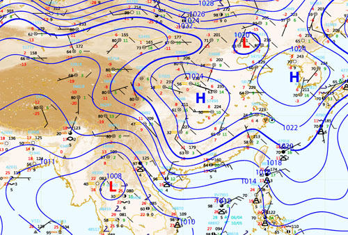
บริเวณที่มีอุณหภูมิสูงจะมีความกดอากาศต่ำ เนื่องจากอุณหภูมิสูง อากาศขยายตัวทำให้มีความหนาแน่นต่ำ อากาศจะลอยไปข้างบน ส่วนบริเวณที่มีอุณหภูมิต่ำ ความหนาแน่นของอากาศจะมากทำให้เป็นบริเวณที่มีความกดอากาศสูง สำหรับแผนที่อากาศจะใช้เส้นไอโซบาร์ (Isobar) เป็นแนวบอกค่าระดับความกดอากาศสูงหรือต่ำ (การอ่านค่าคล้ายกับการอ่าน Contour line : ดูที่ อ่านและแปลความจากเส้นชั้นความสูง) และใช้อักษร H และ L บอกบริเวณหย่อมความกดอากาศ โดยหย่อมความกดอากาศสูงใช้อักษร H หย่อมความกดอากาศต่ำใช้อักษร L
In areas with high temperatures, air pressure is low due to the expansion of air molecules, resulting in low density. The air rises, creating low-pressure areas. Conversely, in regions with low temperatures, the air density is higher, leading to high-pressure zones. Weather maps use isobars as contour lines to indicate the levels of high or low air pressure (similar to reading contour lines). The letter 'H' is used to denote high-pressure areas, while 'L' is used for low-pressure areas.
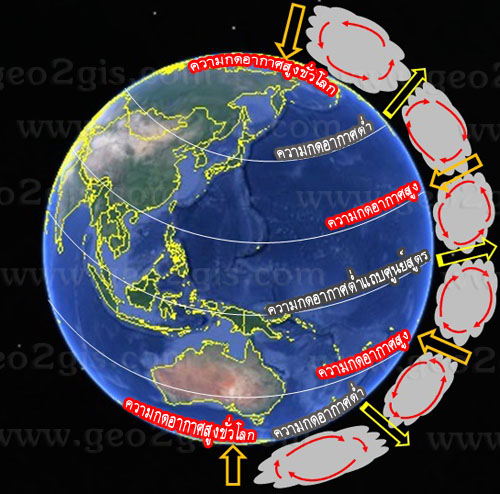
หากพิจารณาการเคลื่อนตัวของอากาศรอบโลกจะพบว่า
A brief explanation of the movement of air around the globe is as follows:
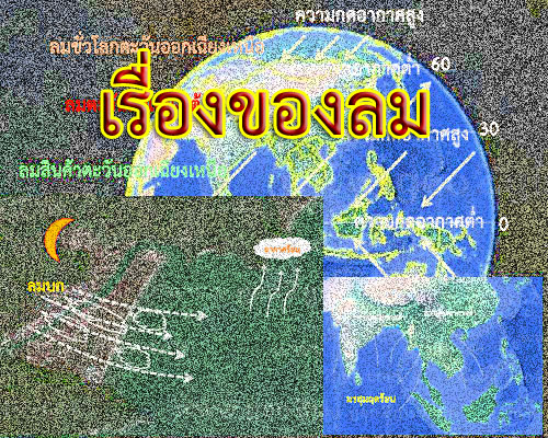
บริเวณเขตเส้นศูนย์สูตรเป็นบริเวณที่ได้รับแสงอาทิตย์ตลอดทั้งปีมีอุณหภูมิสูง อากาศร้อนจะลอยตัวสูงขึ้น(ความกดอากาศต่ำ) ไปจนถึงชั้นบรรยากาศโทรโปสเฟียร์ ซึ่งอากาศจะลอยไม่เกินระดับนี้ อากาศร้อนนี้จึงแผ่ออกไปยังขั้วโลกเหนือและใต้ และเมื่ออากาศร้อนที่แผ่ออกไปปะทะกับอากาศที่เย็นอุณหภูมิก็จะเริ่มลดลงจนถึงบริเวณแถบละติจูด 30° เหนือและใต้ของเส้นศูนย์สูตร อากาศที่เย็นลงเรื่อยๆ (ความกดอากาศสูง) ก็จะจมลงสู่ผิวโลก แต่เนื่องจากอากาศนี้มีความชื้นต่ำจึงทำให้บริเวณนี้แห้ง จึงพบทะเลทรายส่วนใหญ่ของโลกอยู่ในบริเวณนี้
The area along the equator is a region that receives sunlight throughout the year, resulting in high temperatures. The warm air rises, creating low-pressure areas, ascending until it reaches the tropopause. At this level, the air ceases to rise. The warm air then moves towards the Earth's poles, both north and south. When the warm air encounters the cooler air, its temperature begins to decrease, reaching the region around the 30° latitude belts north and south of the equator. The progressively cooler air, characterized by high pressure, descends to the Earth's surface. However, due to the low humidity in this air mass, the region becomes arid, and it is in this area that the majority of the world's deserts are found.
อากาศเย็นที่บริเวณเส้นละติจูด 30° เหนือและใต้ ที่จมตัวลงพื้นผิวโลกเนื่องจากความกดอากาศสูงจะถูกกดและผลักให้ไหลไปยังบริเวณที่มีความกดอากาศต่ำบริเวณเส้นศูนย์สูตร จนถึงบริเวณใกล้เส้นศูนย์สูตรและหมดกำลังทำให้เกิดเขตลมสงบ หรือลมอ่อน (doldrums)
Cool air at the latitude belts around 30° north and south sinks to the Earth's surface due to high air pressure, gets compressed, and is then pushed towards the regions with low air pressure along the equator. This process continues until reaching the vicinity of the equator, where the forces balance out, resulting in the creation of a calm and light wind zone known as the doldrums.
ในขณะที่อากาศเย็นตัวที่จมลงกลับสู่ผิวโลกที่บริเวณเส้นละติจูด 30° เหนือและใต้ที่จมตัวลงพื้นผิวโลกเนื่องจากความกดอากาศสูงอีกส่วนหนึ่ง จะถูกกดและผลักให้ไหลไปทางขั้วโลกเหนือและใต้ และไปปะทะกับอากาศเย็นจากขั้วโลก แถบบริเวณเส้นละติจูด 60° เหนือและใต้ จึงเรียกบริเวณนี้ว่า แนวปะทะขั้วโลก (polar fronts) การปะทะกันของอากาศที่มีอุณหภูมิต่างกัน ทำให้อากาศร้อนกว่าลอยตัวขึ้นโดยส่วนหนึ่งไหลย้อนกลับไปทางเส้นศูนย์สูตร ก่อนที่จะจมตัวลงแถบบริเวณเส้นละติจูด 30° เหนือและใต้อีกครั้งทำให้เกิดความกดอากาศสูงที่บริเวณนี้เพิ่มขึ้น อีกส่วนหนึ่งไหลเคลื่อนไปยังเขตขั้วโลกเหนือและใต้ปะทะกับอากาศเย็นขั้วโลกและจมลง แล้วไหลย้อนกลับไปยังบริเวณเส้นละติจูด 60° เหนือและใต้
While the sinking cool air returns to the Earth's surface around the latitude belts of 30° north and south, driven by high air pressure, another portion of it is compressed and propelled towards the Earth's poles, both north and south. It then meets with the cold air from the polar regions around the latitude belts of 60° north and south. We know this area as the polar fronts, where the collision of air masses with different temperatures occurs. The warmer air, in part, rises and flows back towards the equator before sinking again in the latitude belts around 30° north and south. This process leads to the formation of high air pressure in this region. Another portion of the air moves towards the polar regions, collides with the cold air there, and sinks, then flows back towards the latitude belts of 60° north and south.