


สำหรับลมสินค้าตะวันออกเฉียงใต้ที่พัดขนานชายฝั่งตะวันตกของทวีปอเมริกาใต้แถบเอกวาดอร์ เปรูและชิลี ถูกการหมุนรอบตัวเองของโลกผลักดันให้พัดห่างจากฝั่งออกไปทางตะวันตก โดยลมสินค้าตะวันออกเฉียงใต้ได้พัดเอาผิวน้ำทะเลที่อุ่นจากการรับแสงอาทิตย์ไหลไปทางตะวันตกด้วย
For the Southeast Trade Winds that blow parallel to the western coast of South America along the Equatorial Pacific region, from the eastern Pacific to the western coast of South America, the Earth's self-rotation causes them to veer away from the coast towards the west. The Southeast Trade Winds thus carry warm sea surface waters, heated by sunlight, towards the west.
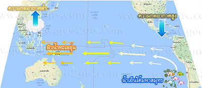
- น้ำอุ่นที่ไหลมาจากแปซิฟิกตะวันออกได้ไหลมารวมกันทางแปซิฟิกตะวันตก ด้วยปริมาณและอุณหภูมิที่สูงขึ้น น้ำทะเลจะลอยและกลั่นตัวเป็นเมฆและตกมาเป็นฝนทำให้บริเวณตะวันออกและตะวันออกเฉียงใต้ของเอเชีย รวมทั้งตอนเหนือของออสเตรเลียมีความชุ่มชื้นฝนตกชุกสามารถทำการเกษตรได้ดี
The warm water flowing from the eastern Pacific converges in the western Pacific, accompanied by increased quantities and higher temperatures. This warm seawater evaporates, forming clouds that result in heavy rainfall over the eastern and southeastern parts of Asia, including the northern region of Australia. This moisture-rich rainfall is conducive to agriculture in these areas.
- ในขณะที่แปซิฟิกตะวันออกแถบชายฝั่งเอกวาดอร์ เปรูและชิลี ผิวน้ำทะเลที่อุ่นซึ่งไหลไปทางตะวันตกทำให้น้ำเย็นที่อยู่ด้านข้างล่างทะเลและอุดมด้วยธาตุอาหารได้ไหลขึ้นมาแทนที่ด้านผิวทะเล ส่งผลให้สัตว์น้ำบริเวณนี้มีอาหารอุดมสมบูรณ์ การแพร่พันธ์และขยายพันธ์เป็นไปได้อย่างดี
While in the eastern Pacific along the Equatorial Pacific region, from the western coast of South America along Ecuador, Peru, and Chile, the warm sea surface water flowing westward displaces the cooler, nutrient-rich waters from the lower depths. This upward movement of nutrient-rich waters to the sea surface results in a flourishing ecosystem, providing abundant food for marine life in this area. It fosters successful reproduction and population expansion.
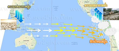
ภาวการณ์เกิดปรากฏการณ์เอลนีโญ
Phenomenon of El Niño occurrence.
ในบางปีที่ความกดอากาศที่ระดับน้ำทะเลบริเวณตะวันออกของมหาสมุทรแปซิฟิกเขตศูนย์สูตร(ชายฝั่งตะวันตกของทวีปอเมริกาใต้แถบเอกวาดอร์ เปรูและชิลี) ต่ำกว่าปกติ ความกดอากาศอีกฝั่งหนึ่งของมหาสมุทร (บริเวณตะวันออกและตะวันออกเฉียงใต้ของเอเชีย รวมทั้งตอนเหนือของออสเตรเลีย) สูงกว่าปกติ
In some years, the atmospheric pressure over the eastern Pacific Ocean, particularly in the central equatorial Pacific region (western coast of South America along Ecuador, Peru, and Chile), is lower than normal. Simultaneously, the atmospheric pressure on the opposite side of the ocean (in the eastern and southeastern parts of Asia, including the northern region of Australia) is higher than normal.
ทำให้ลมสินค้าตะวันออกเฉียงใต้มีกำลังอ่อน เกิดเป็นลมกลับทิศทางพัดพาน้ำทะเลทางด้านตะวันตกของมหาสมุทรแปซิฟิก (ซึ่งปกติมีอุณหภูมิผิวน้ำสูงกว่า) ไปยังบริเวณตอนกลางและตะวันออกของมหาสมุทรแปซิฟิก เข้าสู่ชายฝั่งตะวันตกของทวีปอเมริกาใต้
This leads to the development of a weakened easterly trade wind pattern over the southeastern Pacific, creating a reversal of sea surface currents towards the western and central regions of the Pacific Ocean. This flow extends to the western coast of South America.
ทำให้ด้านตะวันตกของมหาสมุทรแปซิฟิกซึ่งเคยมีฝนตก กลับกลายเป็นบริเวณที่เกิดความร้อนและแห้งแล้งพืชพรรณและการเกษตรเสียหาย ในขณะที่ชายฝั่งตะวันตกของทวีปอเมริกาใต้อุณหภูมิผิวน้ำทะเลกลับอุ่นขึ้นผิดปกติ สัตว์น้ำก็ลดน้อยลง เกิดฝนตกหนัก น้ำท่วม ดินโคลนถล่ม
As a result, the western Pacific Ocean, which used to experience rainfall, transformed into a region characterized by heat and aridity, causing damage to vegetation and agriculture. Meanwhile, the western coast of South America experiences abnormal warming of sea surface temperatures, leading to reduced aquatic life, heavy rainfall, flooding, and landslides.